Submarine Landslides Along the
Northern Puerto Rico-Virgin Islands Margin
Introduction
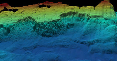
In 1996, a National Science Foundation-funded marine geophysical expedition (EW96-05) provided the necessary data for scientists to compile the first coherent high-resolution bathymetric map of the Puerto Rico Trench (Grindlay et al., 1997). This detailed map, along with newly collected single-channel seismic profiles and high-resolution sidescan sonar imagery, identified the presence of large, scalloped-shaped scarps or "cookie bites" carved out of the northern margin of the Puerto Rico-Virgin Islands carbonate platform. The convex slope margins are common features of carbonate platforms thought to result from large scale erosion. The two scarps show evidence that the northern slope of Puerto Rico has undergone massive submarine slope failure. An important aspect of detailing the submarine slope failures is to identify the potential geohazards submarine mass-wasting events can produce. For example, if a submarine landslide displaces a large enough volume of rock or sediment instantaneously, they can have the potential to contribute to the formation of a tsunami.
 In 1918, an earthquake of magnitude 7.3, centered approximately 15 km off the northwestern coast of Puerto Rico, generated a tsunami that produced a run-up as high as six meters along the western coast of the island (Mercado and McCann, 1998). Because the Caribbean Sea is a seismically active region with a history of earthquakes and since 32 tsunamigenic faults have been identified in the Mona Passage, between the Caribbean Islands of Hispaniola and Puerto Rico, the government of Puerto Rico has implemented a tsunami mitigation program. It is not known whether the tsunami of 1918 is associated with a slope failure event. What is important to note is that under current tectno-sedimentary conditions there does exist the potential for tsunamigenic slope failure along the northern insular slope of Puerto Rico. With increasing global populations and the concentration of much of that population along coastal regions, such geohazards become extremely significant.
This project will focus on a three-dimensional analysis of the scarps along the northern slope using the data collected during the 1996 EW96-05 cruise. The objectives of the project are to quantify the volume of slope-forming material removed in the formation of the scarp located at -66.64° W 18.93° N, map the area of seafloor affected by the debris flow, and evaluate the potential of slope failure given the current tectno-sedimentary environment along the northern margin of Puerto Rico. The results of this study will allow scientists to provide constraints on the significance of local geohazards associated with large volume mass-wasting.
Last updated: January 2004
 In 1918, an earthquake of magnitude 7.3, centered approximately 15 km off the northwestern coast of Puerto Rico, generated a tsunami that produced a run-up as high as six meters along the western coast of the island (Mercado and McCann, 1998). Because the Caribbean Sea is a seismically active region with a history of earthquakes and since 32 tsunamigenic faults have been identified in the Mona Passage, between the Caribbean Islands of Hispaniola and Puerto Rico, the government of Puerto Rico has implemented a tsunami mitigation program. It is not known whether the tsunami of 1918 is associated with a slope failure event. What is important to note is that under current tectno-sedimentary conditions there does exist the potential for tsunamigenic slope failure along the northern insular slope of Puerto Rico. With increasing global populations and the concentration of much of that population along coastal regions, such geohazards become extremely significant.