Submarine Landslides Along the
Northern Puerto Rico-Virgin Islands Margin
Study Area
Tectonic Setting
The relationship
between the North American-Caribbean lithospheric plates is very
complex. Researchers believe that the regional tectonics of
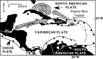
Puerto Rico have been  dominated by an active, left-lateral strike slip boundary between the North American and Caribbean lithospheric plates, although oblique convergence occurs (Masson and Scanlon, 1991; Grindlay et al., 1997, 2000; van Gestel et al., 1998, 1999). At least since the Pliocene, the North American plate has been subducting beneath the Caribbean plate (Grindlay et al., 1997; van Gestel et al., 1998, 1999). Within the zone of oblique strike-slip motion, 75 miles to the north lies the Puerto Rico Trench which has the world's largest negative free-air gravity anomaly. The trench is about 1,100 miles long and 60 miles wide. The deepest point in the Atlantic Ocean, lies at a depth of 27, 493 feet (8,380 meters) in the western end of the trench, about 100 miles northwest of Puerto Rico.
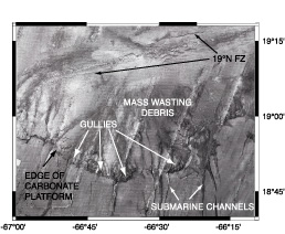
Seismicity in the northeast Caribbean region has been related to the subduction of high-standing ridges on the North American plate. The presence of ridge systems disrupts the normal seafloor patterns entering the Puerto Rico Trench (McCann and Sykes, 1984; Grindlay et al., 2002, submitted). Grindlay et al. (2002, submitted) have hypothesized that as the southeastern Bahama Province and the Main Ridge fracture zone passed from east to west along the Puerto Rico-Virgin Islands (PR-VI) northern margin they caused significant erosion. Aside from increased local seismicity, high-resolution marine geophysical data is used by Grindlay et al. (2002, submitted) to identify other erosional effects such as slope oversteepening, subsidence of the northern margin, and mass-wasting of slope-forming strata. The two, large amphitheater-shaped scarps are evidence that slope failure of the PRVI platform is occurring along the northern insular slope margin of Puerto Rico (Schwab et al., 1991; Grindlay et al., 1997; 2002, submitted).
Amphitheater-Shaped
Scarps Along the Northern Margin of Puerto Rico
(Sidescan imagery of the large scarp processed by Nancy R. Grindlay) 
Scalloped-shaped carbonate platform margins are not atypical features. These characteristic scarps are suggestive of large-scale headward erosion of the platform strata. In a preliminary study, Schwab et al. (1991) was the first to document the presence of a large scalloped-shaped scarp along the northern margin of Puerto Rico. According to higher-resolution sidescan sonar, multibeam bathymetry, and single channel seismic profiling collected during cruise EW96-05, the crown of the headscarp is located at -66.64° W 18.93° N at a depth of ~3 km and extends to the base of the slope at a depth of ~ 6 km. A slightly smaller scarp is discovered further east along the slope margin at 66.18 Ð W 18.86 Ð N. The headscarp
crown of the smaller scarp is ~ 3 km below seasurface and it
tappers off to the slope base at ~ 6.5 - 7 km.
The slope-forming
strata removed in the slope failure events are Oligocene-Pliocene
aged carbonate (Schwab et al., 1991; Grindlay et al., 1997, 2002,
submitted). Of the 36 seismic reflection profiles, line 20
clearly shows the progression of the PRVI upper carbonate strata in
situ along the crown of the scarp to that of the deformed carbonate mass at the base of the slope. The uppermost unit of the carbonate platform, PR megasequence 3, outcrops in the middle of the island of Puerto Rico and decreases significantly in thickness eastward and landward.
 dominated by an active, left-lateral strike slip boundary between the North American and Caribbean lithospheric plates, although oblique convergence occurs (Masson and Scanlon, 1991; Grindlay et al., 1997, 2000; van Gestel et al., 1998, 1999). At least since the Pliocene, the North American plate has been subducting beneath the Caribbean plate (Grindlay et al., 1997; van Gestel et al., 1998, 1999). Within the zone of oblique strike-slip motion, 75 miles to the north lies the Puerto Rico Trench which has the world's largest negative free-air gravity anomaly. The trench is about 1,100 miles long and 60 miles wide. The deepest point in the Atlantic Ocean, lies at a depth of 27, 493 feet (8,380 meters) in the western end of the trench, about 100 miles northwest of Puerto Rico.