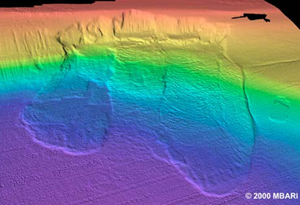
Submarine landslides are common on inclined areas of the seafloor, often in situations of rapid deposition of unlithified, fine grain sediment or fractured rock. When these packages of sediment are subjected to tectonic erosion or seismic strain, such as earthquakes, reduction of pore water pressure occurs and reduces the strength of the strata. Hurricanes, passing storm waves, the presence of gas filled cavities within sediments, and even carbonate dissolution at depth are also capable of reducing the strength of the strata (Hampton 1970; 1972; Summerhayes and Thorpe, 1996). These disturbances reduce the balance of forces that allows the strata to remain in situ. If the force balance is shifted, the result is a downward, outward movement of rock or sediment termed submarine landslide or mass-wasting event. When this type of event occurs along slope margins, they are more commonly referred to as a gravity induced slope failure.

Photo taken from MBARI News - Researchers report on submarine landslide hazards (2000).
Visit this site: http://www.mbari.org/news/news_releases/2000/dec15_greene.html
Submarine landslides can involve the movement of thousands of cubic km of sub-seasurface rock and sediment and can be orders of magnitude greater than their terrigenous counterparts. The Agulhas submarine landslide off South Africa, the largest slope failure documented, involved a volume as large as 20,000 km3 and a runout distance of greater than 140 km (Dingle, 1977). The possibility for the removal of such huge magnitudes of slope-forming sediments indicates that submarine landslides are an important mechanism in the transport of shallow water sediment/rock into deeper waters and in the sculpting of both continental and insular slope margins.
Submarine landslides can be identified by two features: a distinct headwall region (the rupture surface, the headscarp itself) and the removed mass, which usually changes behavior between initiation and final deposition. For example, a cohesive slide block may remain completely intact, break up into smaller pieces, or disintegrate into a flow (Morganstern, 1967; Hampton, 1972). Failures involving slope-forming materials of different lithologies and volume vary in resultant headscarp morphology. Failure events are often categorized by the geomorphology and velocity of the flow into the following categories:
Subaqueous rock fall/avalanche: Little is known about these processes but that rock falls are important in areas of steep topography, like along the walls of fjords and submarine canyons.
Creep: Very slow, periodic movements leaving stair-like topography in its wake.
Translational slides: Commonly move on well-defined slippage planes. It is thought that slides may be the initial stage of larger scale slope failure events.
Rotational slide or slump: Typically leave curved-shaped scar. Displaced mass is usually tilted back against slope as a result of rotation of the unit. Oftentimes, the toe, or the leading edge of the slump, becomes fluidized and evolves into a debris flow.
Debris flows: Gravity induced transport of unlithified fine-grained sediment. The grains are supported by the strength of the surrounding fluid. Debris flows appear to be very common processes capable of transporting sediments far distances even on low slope gradients.
Turbidity currents: These currents are powerful and fast-moving mixes of sediment and water greater in density than the surrounding water. It is thought that turbidity currents result from the deformation of slumps and slides. Deposits resulting from these currents are characteristic and have been labeled as turbidites. Turbidites display a graded bedding of five layers (Bouma Sequence) ranging from coarse grain material on the bottom layer to fine grained sediment on the upper.
An important aspect of detailing submarine slope failures is to identify the potential geohazards submarine mass-wasting events produce. With increasing global populations and the concentration of much of that population along coastal regions, coastal areas face increasing threats from marine geohazards. For instance, if such failures involve a significant volume of rock or sediment in an instantaneous event, the displacement is capable of generating a tsunami such as the ~17 m wave that struck Papua New Guinea in 1998 (McSaveny et al., 2000). The 17 m wave source location was traced to the foot of an amphitheater-shaped scarp 25 km offshore resulting from an eroded/seismically induced sediment slump (McSaveny et al., 2000).
A slide and resulting debris flow involving the displacement of 20 by 33 km block of slope-forming materials on the mid-slope of the Peru trench is thought to have contributed to the generation a 50 m wave locally onshore (vonHeune et al., 1989).
The ~3000 cubic km Ruatoria debris avalanche along the northern Hikurangi margin of New Zealand was largely the result of slope failure along an instable groove-like indentation left behind from the oblique subduction of a seamount (Callot et al., 2001).
A comparable tectonic environment along the northern insular margin of Puerto Rico and the Virgin Islands may pose a similar threat to the inhabitants of the island of Puerto Rico, most of which live along the coast. This project focuses on the assessment of the magnitude and discussion of possible mechanisms and repercussions for the slope failure events that created the giant, amphitheater-shaped scarps along the northern insular margin of Puerto Rico. High-resolution marine geophysical mapping efforts, such as the EW96-05 cruise, are essential in the determination of slope stability; more specifically, where mass movements are likely to occur in the future, what magnitude of materials might be involved, and what repercussions might be associated with the transport processes.
Additional links: