Sediment Recycling: Marsh Renourishment Through Dredged Material Disposal
Project Summary
Tidal marshes constitute important recreational and economic resources that provide significant economic and social benefits for many coastal states. In the southeastern United States alone, approximately 17.2 million acres of marsh and estuarine habitat exist, and the economy of many coastal communities is based on commercial fisheries that rely on high quality marsh habitat. As population growth and development have increased in the coastal zone in recent years, however, multi-use coastal management practices have negatively impacted the natural processes of marsh accretion. Inlet stabilization practices, post-storm bull dozing, and beachfront development have interrupted the natural supply of inorganic material to back barrier marshes. The consequence is that some systems are beginning to show signs of deterioration.
One way by which sediment deficits may be offset is by artificially
introducing inorganic sediment, specifically dredged material, in deteriorating marshes.
The benefits of this method are two-fold. First, marsh stability is enhanced and second,
the "spoil" is used beneficially. The goal of this study is to develop a
methodology of sediment placement that offsets elevation losses in deteriorating marshes
without decreasing productivity and/or diminishing functionality. The specific objectives
of this study are 1) to determine maximum sediment addition depths in tidal marshes that
optimize elevation maintenance without compromising microalgal and vascular plant biomass,
or community structure of resident fauna, 2) to determine how frequency of marsh
nourishment affects biotic responses, and 3) to disseminate project results to a range of
potential users through multimedia and on-site experience. This research will consist of
several experiments designed to test the effect of spraying sediments in discrete
increments, at different rates, on the surfaces of deteriorating and stable tidal marshes
in the Masonboro Estuarine Research Reserve, NC. The response of vascular plants,
microalgae, and benthic fauna to sediment additions will be assessed. Changes in sediment
delivery and soil chemistry will also be examined. This project will constrain the volumes
of sediment, and rates of input, that can restore degrading marsh without adversely
effecting ecosystem function. Our results will assist in the establishment of management
guidelines for use of this novel option for the disposal of dredged material and will
suggests applications where this methodology can be used to bolster recipient marshes
against losses due to natural or anthopogenically induced subsidence.
Study Area
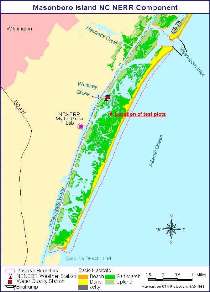
This project is being conducted in the Masonboro Island component of the North Carolina Estuarine Research Reserve. Masonboro Island is a barrier island located in New Hanover County between the barrier island towns of Wrightsville Beach and Carolina Beach. The city of Wilmington lies 5 miles to the northwest. The study plots established for this project.
The map below was created by NERR staff ( http://inlet.geol.sc.edu/NOC/masonboro_jan99.jpg):

Progress to Date
********THIS PROJECT HAS BEEN GRANTED PERMIT NUMBER 41-00 FROM THE STATE OF NORTH CAROLINA TO CONDUCT THIS PROJECT. PERMIT EXPIRES ON DECEMBER 31, 2003.************
For more information, please contact:
Lynn A. Leonard lynnl@uncwil.edu