Hydrology and Salinity
The hydrologic models developed for the Cape Fear River deepening project predict that tidal amplitudes north of Wilmington will increase by 4 inches following project completion and may result in conversion of riparian wetlands to tidal swamps. The first goal of the project is to determine the baseline hydrology and salinity levels in the Cape Fear and Northeast Cape Fear Rivers and adjacent wetlands. These data will be used to refine the existing model and to more accurately assess the impact of the deepening project. Tidal data measured at upstream sites will be compared to data collected at the river mouth (station P1) before and after dredging. Increased tidal amplitude is expected to have the greatest potential impact on adjacent wetland systems when salt is present in the floodwater at a station.
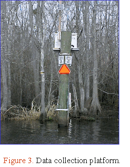
Data collection platforms
(DCPs) have been installed at each of 11 stations in the study area (Figure
3). Each DCP consists of a data logger, a water level gauge, and
a conductivity sensor contained in weather proof housing and mounted on
pilings at the edge of the stream. Water level is scanned at 1Hz and the
mean, maximum and minimum values are logged every 3 minutes. Conductivity
and temperature are scanned and recorded every 3 minutes. Automated water
level recorders and conductivity meters are deployed twice annually at
each wetland substation for a 2 week period in spring and fall. Water level
is sampled and recorded at 24 minute intervals and conductivity and temperature
are sampled and recorded at 6 minute intervals.
Preliminary Results
All of the sites in the monitoring area are affected by tides (Figure 4). Water level data collected at Station P1 reflect a typical oceanic tidal signature for this region. In general, tidal range decreases at upstream stations. Tidal asymmetries are seen at all stations in the study area. For example, at P1, ebb flow occurs for a shorter time period (5 h 36 m) than flood flow (7 h). At P6, the duration of ebb and flood are 6 h 43 m and 6 h 12 m, respectively. Further upstream, at P9, the ebb tide lasts longer (7 h) than the flood tide (6 h 24 m) (Figure 5).